 |
surfresearch.com.au
cook : polynesian surf-riding, circa 1779 |
| home | catalogue | history | references | appendix |
|
Excerpt
2 : George Gilbert, midshipman 'Resolution'.
Surfboard
Paddling
Kealakekua Bay,
Hawaii.
February, 1779.
Excerpt
3 : David Samwell, Surgeon's Mate, 'Resolution'.
Surf-riding
Kealakekua Bay,
Hawaii.
22nd January,
1779.
Excerpt
4 : James King's Unedited log
Surf-riding
Kealakekua Bay,
Hawaii.
March 1779.
Excerpt
5 : James King's Edited Log
Surf-riding
Kealakekua Bay,
Hawaii, March 1779.
Reproduced in:
Zug, James: The Last Voyage Of Captain
Cook: The Collected Writings of John Ledyard
National Geographic Society, Washington,
D.C., U.S.A., 2005.
On the 17th January, 1779, we entered
our harbour, which was a comodious bay situate nearly in the middle of
the south side of Owyhee, and about a mile and a half deep, the extremes
of the bay distant about two miles.
We entered with both ships, and anchored
in 7 fathoms water about the middle of the bay having on one side a town
containing about 300 houses called by the inhabitants Kiverua, and on the
other side a town containing 1100 houses, and called Kirekakooa.
While we were entering the bay which
they called Kirekakooa after the town Kirekakooa we were surrounded by
so great a number of canoes that Cook ordered two officers into each top
to number them with as much exactness as they could, and as they both exceeded
3000 in their amounts I shall with safety say there was 2500 and as there
were upon an avarage 6 persons at least in each canoe it will follow that
there was at least 15000 men, women and children in the canoes, besides
those that were on floats, swimming without floats, and actually on board
and hanging round the outside of the ships.
The crouds on shore were still more
numerous.
The beach, the surrounding rocks, the
tops of houses, the branches of trees and the adjacent hills were all covered,
and the shouts of joy, and admiration proceeding from the sonorous voices
of the men confused with the shriller exclamations of the women dancing
and clapping their hands, the overseting of canoes, cries of the children,
goods on float, and hogs that were brought to market squalling formed one
of the most tumultuous and the most curious prospects that can be imagined.
NOTES
While James Zug notes in his introduction
(page XXI and following) that Ledyard substantially plagerized several
of the available published accounts of Cook's voyages, this is the only
written report of surfboards ("floats") in use as water transport
on the expedition's initial entry into Kealakekua
Bay, Hawaii, on 17th January 1779.
As such it confirms the illustration by
John Webber,
see below.
Ledyard's estimation of the number of
canoes and their occupants is significantly larger than reported by King:
"about the Resolution 500 Canoes and about the Discovery
475", see below.
Possibly from
Christine Holmes
(editor). Captain Cook's Final Voyage: The Journal of Midshipman George
Gilbert.
: Caliban Books,
Horsham, Sussex. University of Hawaii Press. 1982. Page?
They lay themselves upon it length ways, with their breast about the centre; and it being sufficient to buoy them up they paddle along with their hands and feet at a moderate rate, having the broad end foremost (5); and that it may not meet with any resistance from the water, they keep it just above the surface by weighing down upon the other, which they have underneath them, betweeen their legs. (6)
These pieces of wood are so nicely balanced that the most expert of our people at swimming could not keep upon them half a minuit without rolling off." (7)
NOTES
1.
"have a method of swimming upon a piece of wood"
This reference only
records the use of a surfboard as a mode of transport, as illustrated in
Webber's
illustration
and does not indicate surf-riding activity.
This overwise simple
observation, may however establish a relationship between board paddling
and the development of Polynesian swimming technique - the overarm
stroke with flutter kick.
2. "form of
a blade of an oar"
Indicates the board
was flat and probably possiblyly with a rounded, not a square, nose.
3. "about six
feet in length, 16 inches in breadth at one end and about nine at the other,
tapering
down
These dimensions
are close to Samwell's "a thin board about
six or seven foot long & about 2 (foot) broad "
Dimensions are not
included in either of the published entries attributed to James
King.
Significantly, this
report notes the characteristics of the template, probably 16'' wide near
the nose and a 9'' tail.
4. "four or
five inches thick, in the middle tapering down to an inch at the sides.""
The thickness and
rail taper are also not included in the other reports from the voyage.
The thickness seems
extreme compared with later accounts and to existing examples from the
period.
5. "having
the broad end foremost"
The widest part
of the board is the nose.
6. "They lay
themselves ... betweeen their legs."
A detailed account
of the mechanics of board paddling.
7. "... the
most expert of our people ..."
Patrick Moser noted,
July 2006 (see Correspondence) "This last observation
at leasts suggests that some of Cook's men may have tried paddling (or
surfing?) on these boards themselves."
I would contend
that the report specifically records attempts by members of the crew
to paddle the boards, without success.
The skill of board
paddling is fundamental to successful surf-riding and it is often overlooked
by modern commentators.
The report is also
consistant with Ellis' comment (see Point 5) that
implies the boards have been examined closely and must have been held to
report the weight.
Furthermore, the
sentence also conforms with the relective nature of the account, that probably
indicates it is based on multiple observations.
GEORGE GILBERT
"George Gilberts
writing has been lauded as even-handed, even mature, reminiscent of the
magnificent lack of imagination displayed by the younger James Cook in
his Endeavour journal.
George Gilbert
joined Captain Cooks 1776 expedition as a seaman and was promoted to midshipman
during the voyage.
His father
George Gilbert had served as master on the the 'Resolution' for its preceding
voyage to the Pacific, during which time Cook had named Gilbert Island
off the coast of Tierra del Fuego for him. Upon his fathers retirement,
John Gilbert had been replaced as master by William Bligh, later deposed
as captain during the mutiny on the Bounty.
While in his
late teens or early twenties, Gilbert was on the 'Resolution' when Cook
visited Nootka Sound and undertook repairs from late March 1778 until April
27.
His extensive
account of their travels was not included within The Journals of Captain
Cook. Vol. 3. Parts 1 & 2, Resolution and Discoveryas were extracts
from journals by his contemporaries Anderson, Clerke, Burney, Williamson,
Edgar and Kingbecause Gilberts 325-page manuscript journal was likely
completed in the early 1780s.
Gilberts memoir
was not published until two centuries later, 80 years after a descendant
of Gilberts brother, Richard Gilbert, took the manuscript to the British
Museum in 1912.
...
After Cooks
death, Gilbert transferred to the 'Discovery' under Captain Clerke and
was paid off at Woolwich on October 21, 1780.
He became
fifth lieutenant on the warship 'Magnificent' until 1783.
The year and
nature of his death are not known.
Gilberts
original journal is in the British Museum."
2. Following
the posting of Samwell's account to Joe Tabler
at surfbooks.com, I was contacted in July 2006 by Patrick Moser,
Drury University, who provided the complete Gilbert quotation, as posted
above.
Patrick Moser also
provided the date, a probable location and noted ...
This last observation
at leasts suggests that some of Cook's men may have tried paddling (or
surfing?) on these boards themselves.
See Point 7. above,
full email attached below.
Thanks to Patrick
Moser for his substantial contribution to this subject.
"As two or three of us were walking along shore to day we saw a number of boys & young Girls (1) playing in the Surf, which broke very high on the Beach as there was a great swell rolling into the Bay. (2)
In the first place they provide themselves with a thin board about six or seven foot long & about 2 broad (3) , on these they swim off shore to meet the Surf (4) , as soon as they see one coming they get themselves in readiness & turn their sides to it (5) , they suffer themselves to be involved in it (6) & then manage so as to get just before it or rather on the Slant or declivity of the Surf (7), & thus they lie with their Hands lower than their Heels laying hold of the fore part of the board which receives the force of the water on its under side (8) , & by that means keeps before the wave which drives it along with an incredible Swiftness to the shore. (9)
The Motion is so rapid for near the Space of a stones throw that they seem to fly on the water, the flight of a bird being hardly quicker than theirs.
On their putting off shore if they ...
Page 1165
... meet with
the Surf too near in to afford them a tolerable long Space to run before
it they dive under it with the greatest Ease (10)
& proceed
further out to sea. (11)
Sometimes they fail in trying to get before the surf, as it requires great dexterity & address, and after struggling awhile in such a tremendous wave that we should have judged it impossible for any human being to live in it, they rise on the other side laughing and shaking their Locks & push on to meet the next Surf when they generally succeed, hardly ever being foiled in more than one attempt. (12)
Thus these People find one of their Chief amusements (13) in that which to us presented nothing but Horror & Destruction, and we saw with astonishment young boys & Girls about 9 or ten years of age (14) playing amid such tempestuous Waves that the hardiest of our seamen would have trembled to face, as to be involved in them among the Rocks, on which they broke with a tremendous Noise, they could look upon as no other than certain death. (15)
So true it is that many seeming difficulties are easily overcome by dexterity & Perseverance. (16)"
NOTES
1. "a number
of boys & young Girls"
Samwell notes that
surf-riding is a community activity including both sexes and juvenile riders.
He later makes his
remarks more specific, see 13.
2. "a great
swell rolling into the Bay."
Suitable swell conditions
are not consistently available and in this case breaking close to the shore.
3. "a thin
board about six or seven foot long & about 2 (foot) broad "
This dimensions
appear practical and are close to Gilbert's "about six feet
in length, 16 inches in breadth" - see Extract 1.
4. "swim off
shore to meet the Surf "
Paddling out through
the surf line.
5. "in readiness
& turn their sides to it"
The rider's preparation
and positioning for the take-off.
6. "to be involved
in it"
Possibly indicates
a take-off in the white-water or the broken water of a wave.
Technically a wave
of translation.
7. "get just
before it or rather on the Slant or declivity of the Surf"
This appears to
indicate the riders attempt to ride on the sloping wave face, in preference
to the white-water.
declivity : a downward
slope, Macquarie Dictionary (1991).
8. "lie
with their Hands lower than their Heels laying hold of the fore part of
the board which receives the force of the water on its under side"
Classic prone surf-riding
technique.
Possibly indicates
that the rider's feet were raised out of the water.
9. "an incredible
Swiftness to the shore."
The speed of the
riders is often reported by early observers, this may indicate that "swiftness"
was a factor of angling across the wave face and travelling faster than
the wave speed.
Banks (1769) uses
exactly the same expression.
See Banks
: Tahiti 1769 Note 12.
10. "too near
in to afford them a tolerable long Space to run before it they dive under
it with the greatest Ease"
In contemporary
surf-riding terminology, this manoeuvre is known as a 'duck-dive" and was
first illustrated by
Wallis McKay, circa
1874.
Also reported by
Banks,
Note 14.
11. "&
proceed further out to sea."
A continuous process
of wave riding followed by paddling back out through the surf.
12. "Sometimes
they fail in trying to get before the surf, as it requires great dexterity
& address, and after struggling awhile in such a tremendous wave that
we should have judged it impossible for any human being to live in it,
they rise on the other side laughing and shaking their Locks & push
on to meet the next Surf when they generally succeed, hardly ever being
foiled in more than one attempt."
The most dramatic
feature of this account, the sentence may indicate that if the rider is
unable to maintain a position on the wave face ("fail in trying to
get before the surf") they may be caught and enveloped in the white-water
- "in such a tremendous wave ... impossible for any human being
to live in it".
At an extreme (certainly
not fully confirmed by the text), this section could be interpreted see
as the first description of a "tube-ride" or "cover up".
Modern Boogie riders
frequently ride so far back in the curl that the impact zone eventually
propels the rider out the back of the wave - "they rise on the other
side".
Despite Samwell's
practical assessment of the intrinsic danger of the activity ( see Note
14, below), the rider's treat the situation with disdain - "laughing
and shaking their Locks".
13. "Thus these
People find one of their Chief amusements"
Given the generality
of this comment, it may indicate that Samwell had previously viewed
the activity and/or that he had heard other reports by members of the crew.
14. "young
boys & Girls about 9 or ten years of age"
Samwell attempts
to specifically estimate the age of some of the participants, see Note
1.
15. "no other
than certain death."
Certainly for a
18th century European, who probably could not swim, the activity was extreme.
The inherent danger
of the activity is often overlooked by surf-experienced commentators.
16. "So true
it is that ... Perseverance."
Samwell draws a
philosophical conclusion.
DAVID SAMWELL
"David Samwell
sailed on the Third Voyage on the Resolution as Surgeon's mate, later transferring
to the Discovery.
He was born
in Nantglyn, Wales in 1751 and died in London in 1798.
Prior to his
death he had been a surgeon to British troops at Versailles in France.
Samwell kept
a journal on the Third Voyage, which contains one of the most detailed
descriptions of the events surrounding Cook's death.
He was also
a respected poet who wrote verse in English and Welsh and was honoured
at eisteddfods.
There is a
short biography of him in the Dictionary of National Biography (vol.17,
p.732)."
Beaglehole, John
C. (editor) : The Voyage of the Resolution and Discovery 1776 - 1780.
Cambridge Hakluyt
Society, Two Volumes.
Volume 1, page 268.
1967.
Reprinted in Finney,
Ben and Houston, James D. :
Surfing
A History of the Ancient Hawaiian Sport. 1996. Appendix B. Page
97.
Page 592.
These Plantations
in many places they carry six or seven miles up the side of the hill, when
the woods begin to take place which diffuse themselves from hence to the
heights of the eminences and extend over a prodigious track of ground;
in these woods are some paths of the Natives and here and there a temporary
house or hut, the use of ...
Page 593.
which is this; when a man wants a Canoe he repairs to the wood and
looks about him till he has found a tree fit for his purpose and a convenient
spot for his work; having succeeded thus far, he runs up a house for his
present accommodation and goes to work upon his Canoe, which they in general
compleatly finish before it's moved from the spot where its materials had
birth.
Our people who made excursions about the Country saw many of these
Canoes in different states of forwardness, but what is somewhat singular,
if one of their vessels want repairing she is immediately removed into
the woods though at the distance of 5 or 6 miles.
<...>
These people are exceedingly populous; the day we went first into
Care'ca'coo'ah Bay there were counted about the Resolution 500 Canoes and
about the Discovery 475, a great many of these were large double Boats
carrying ten or twelve Men so that here was a vast concourse of People;
however many of these were assembled from various parts of the Isle, and
some I know came from the Isle of Mow'wee, but the immense number of Men
and women living in the various villages about this Bay surpassed every
idea of populousness I could ever form, and the abundant stock of Children
promised very fairly a plentiful supply for the next Generation.
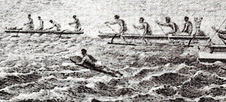
"But a diversion the most common is upon the Water, where there is a very great Sea, & surf breaking on the Shore.
The Men sometimes 20 or 30 go without the Swell of the Surf, & lay themselves flat upon an oval piece of plank about their Size & breadth (1), they keep their legs close on top of it, & their Arms are us'd to guide the plank, they wait the time of the greatest Swell that sets on Shore, & altogether push forward with their Arms to keep on its top (2), it sends them in with a most astonishing Velocity & the great art is to guide the plank so as always to keep it in a proper direction on the top of the Swell, & as it alters its directn (3).
If the Swell drives him close to the rocks before he is overtaken by its break; he is much prais'd.
On first seeing this very dangerous diversion I did not conceive it possible but that some of them must be dashed to mummy against the sharp rocks, but just before they reach the shore, if they are very near, they quit their plank, & dive under till the Surf is broke, when the piece of plank is sent many yards by the force of the Surf from the beach.
The greatest number are generally overtaken by the break of the swell, the force of which they avoid, diving & swimming under the water out of its impulse.(4)
By such like excercises, these men may be said to be almost amphibious.
The Women could swim off to the Ship, & continue half a day in the Water, & afterwards return.
The above diversion is only intended as an amusement, not a tryal of Skiil, & in a gentle swell that sets on must I conceive be very pleasant, at least they seem to feel a great pleasure in the motion which this Exercise gives. (5)"
NOTES
In the unedited
version, a close reading indicates that King has understood and related
...
1. "an oval
piece of plank about their Size & breadth"
Notes a shaped the
nose and maybe tail, the dimensions are difficult to estimate.
Probably not longer
than the rider's height, this width could vary from 15'' to 20'' for adult
riders.
They may have approximated
six feet long and by eighteen inches wide (6ft x 18'').
2. The
necessary dynamics of wave selection and the critical nature of take-off
positioning ..
"wait the
time of the greatest Swell ...(and) push forward with their Arms to keep
on its top"
3. The necessary
dynamics of positioning the board in the correct planning angle on the
wave face ..
"the great
art is to guide the plank so as always to keep it in a proper direction
on the top of the Swell."
Subsequent accounts
also confirm the neccessity of adjusting the board to the
correct planning angle on the wave face for successful surf-riding.
This was noted by
Blake
(1935, pages 41 - 42. ) and Finney
and Houston (1966, page ?) as strong evidence that the ancient
Hawaiians rode waves, in this respect, in exactly the same manner as (their)
contemporary surf-riders.
4. The method
of negotiating the difficulty of paddling out through the surf...
"the force
of which they avoid, diving & swimming under the water out of its impulse."
5. The excitement
and exhilaration of the activity ....
"they seem
to feel a great pleasure in the motion which this Exercise gives."
JAMES KING R.N.
These extracts,
dated March 1779, are taken from two published versions of the expedition's
log.
For the first account
of a previously unencounted and dynamically difficult activity, the information
of the combined versions is remarkable.
It clearly demonstrates
the powers of observation and critical analysis required by an officer
in the British navy in the 18th century and an appreciation of skilled
maritime activity.
King's account is
probably based on examining the surf-riding on a number of occasions.
It is possible that
on occasion, King's observations were from a boat on the water.
There are significant
differences in the two accounts.
Finney
and Houston (1996) caution that
"... the official
publication ... was heavily edited by ... Douglas ... adding marterial
of his own and from other accounts of the voyage." - Footnote,
Page 32.
Given that the additional
details of the edited version closely correspond with modern surf-riding
experience, in this case the information is unlikely to be from Douglas'
imagination and more likely from other eye-witness sources.
Cook, James and King,
James :
A Voyage to the
Pacific Ocean Undertaken by Command of his Majesty For Making Discoveries
in The Northern Hemisphere Performed Under Captains Cooke, Clerke, Gore
in Years 1776, 1777, 1778, and 1780, being a copious and Satisfactorary
Abridgement.
Douglas, Reverend
John (editor)
G. Nicholl and T.
Cadell, London, page ?. 1784.
Second Edition
A New, Authentic
and Complete Collection of Voyages Round the World, Undertaken and Performed
by Royal Authority. Containing an Authentic, Entertaining, Full, and Complete
History of Capt. Cook's First, Second, Third and Last Voyages
Anderson, George
William (editor).
(London, 1784-1786).
Translations
Neueste Reisebeschreibungen;
oder, Jakob Cook's dritte und letzte Reise . . . in den Jahren 1776 bis
1780. (Nuremberg, 1786). [An example of many translated versions.]
Reprinted in Finney,
Ben and Houston, James D. :
Surfing
A History of the Ancient Hawaiian Sport. 1996. Chapter 3. Page
32.
The first wave they meet, they plunge under, and suffering it to rollover them, rise again beyond it (3), and make the best of their way, by swimming, out into the sea.
The second
wave is encountered in the same manner with the first ...
As soon as
they have gained by these repeated efforts, the smooth water beyond the
surf, they lay themselves at length on their board, and prepare for their
return.
As the surf consists of a number of waves (4), of which every third is remarked to be always much larger than the others, and to flow higher on the shore, the rest breaking in the intermediate space, their first object is to place themselves on the summit of the largest surge ....
If by mistake
they should place themselves on one of the smaller waves, which breaks
before they reach the land, or should not be able to keep their plank in
a proper direction on the top of the swell,
they are left
exposed to the fury of the next, and, to avoid it, are obliged again to
dive and regain their place, from which they set out. (5)
Those who succeed
in their object of reaching shore, have still the greatest danger to encounter.
The coast
being guarded by a chain of rocks, with, here and there, a small opening
between them, they are obliged to steer their boards through one of these
(6),
or, in case of failure, to quit it, before they reach the rocks, and, plunging
under the wave., make the best of their way back again.
This is reckoned very disgraceful, and is also attended with the loss of the board, which I have often seen, with great horror, dashed to pieces, at the very moment the islander quitted it. (7)"
NOTES
The edited version
notes ...
1. The challenge
of extreme conditions ..
"Whenever
... the impetuosity of the surf is increased to its utmost heights, they
choose that time for their amusement,"
2. "a long
narrow board, rounded at the ends"
Vague and indeterminate
dimensions, but notes shaped the nose and maybe the tail.
3. A sophisticated
method of negotiating the (breaking) wave zone by a co-ordinated submerging
of board and
body through the
base of an approaching wave.
In contemporary
surf-riding this is known as a "duck-dive".
Although commonly
used by body-surfers, it is more difficult when attempted with a board.
"The first
wave they meet, they plunge under, and suffering it to rollover them, rise
again beyond it ..."
4. The recognition
that waves come in 'sets' ...
"As the surf
consists of a number of waves"
5. The difficulties
of miscalculation in wave selection, resulting in "getting it on the head"
...
"by mistake
they should place themselves ..., they are left exposed to the fury of
the next"
6. The potential
danger to the rider and the difficulty in negotiationing a rocky shoreline
to return safely to the beach ...
"The coast
being guarded by a chain of rocks ... they are obliged to steer their boards
through".
7. The
potential danger to the rider and the board if they are separated ...
"the loss
of the board ... dashed to pieces, at the very moment the islander quitted
it."
 |
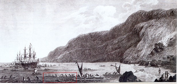
Detail from John Webber : A View of KaraKakooa, in Owyhee. An engraving based on an original drawing at Kealakekua Bay, 1779. Printed in the official account of the voyage, Plate 68. See reference below. |
Resolution
and Discovery, the ships of James Cook's third Pacific expedition,
initially anchored and landed at Waimea River mouth, Kaui on 20th January
1778, staying for four days.
Finney
and Houston (1996), page 31, identify three ancient surf-riding
sites at Waimea River mouth, Kauai.
Departing on 24th
January, the next anchorage and landfall was near Leahi Point on the island
of Nihau on 29th January 1788.
After a further
stay of approximately four days, Cook left on 2nd February 1778 to explore
the North West Pacific.
Finney
and Houston (1996) identify one ancient surf-riding site
near Leahi Point, Nihau, page 31.
Cook's expedition
returned to the Hawaiian Islands on 26th November 1778.
Without landing,
he met with Kalani'opu'u (the king of the island of Hawaii) off the coast
of Maui near Kahului on the following day and subsequently set sail for
the big island.
The prevailing weather
conditions and the failure to locate an anchorage suitable to Cook's requirements,
delayed a landing until 16th January 1789.
The arrival in Kealakekua
Bay, Hawaii was greeted by over a thousand canoes as illustrated by John
Webber's "A View of KaraKakooa, in Owyhee, 17 January 1779."
This is the first
European depiction of a surf-board. See below.
Finney
and Houston (1996) identify one ancient surf-riding site
specifically at Kealakekua Bay, Hawaii.
Furthermore, they
identify another thirty two ancient sites within approximately 30 kilometres
(23 miles) of Kealakekua Bay, pages 28 and 29.
After an extended
stay of nineteen days, the ships left Kealakekua Bay on 4th February 1779.
Unfortunately for
Cook, Resolution's mast broke after two days sailing and he was
forced to return to on the 11th February.
Simmering cultural
differences resulted in a violent confrontation on the 14th February wherein
Cook, and twenty-one others, died.
Command of the expedition
fell to Charles Clerke, previously the captain of the Discovery,
who was able to restore relations.
Clerke determined
that he should continue to fulfil Cook's orders and the expedition left
Kealakekua Bay for the North Pacific on 22nd February, 1779.
The return necessitated
by Resolution's broken mast lasted eleven days, which brings to
a total of thirty days that Lt. King spent in and around Kealakekua Bay,
Hawaii.
The next anchorage
was three weeks later at Waimea Bay, Ohau, on the 27th February, but was
only for one night and they sailed west on the 28th.
Finney
and Houston (1996), page 38, identify one ancient surf-riding
site specifically at Waimea Bay, Ohau.
On the 2nd March
1779, the expedition returned to its previous anchorage at Waimea Bay on
Kaui.
Relations were strained
(mostly due to local problems) and after a stay of six days, Clerke relocated
to the previously used anchorage off Leahi Point, Nihau on the 8th March.
This was the final
landfall in the Hawaiian Islands, a stay of five days.
The expedition departed
for Kamchatka on the 15th March, 1779.
In total the ships
of Cook's third pacific expedition were anchored in Hawaiian waters for
49 days.
The longest was
at Kealakekua Bay, Hawaii (30 days) but much of the return visit would
have been preoccupied with Cook's violent death and its aftermath.
It would appear
that Lt King's observations were most probably at, or around, Kealakekua
Bay.
Note that there
are no reports from Hilo Bay on Hawaii or Wakiki on Ohau, apparently the
two major centres of ancient Hawaiian surf-riding.
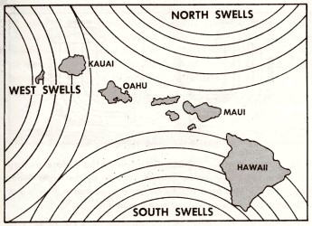
Also note that at
this time of the year the predominant swell direction is the famed winter
swells originating in the North Pacific, and the extended anchorage's were
all on the southern coasts.
Generally, the southern
coasts best surf-riding conditions are with the summer swells from the
southern ocean, although some may also be exposed to winter swell from
the west. See below.
If the Kona coast
surf-riders had been questioned as to the suitability of the conditions,
their response may have translated as approximately ...
The one northern
anchorage, at Waimea Bay on the island of Ohau, was only for one night
(27 - 28 February 1779).
Given the modern
reputation of this location for big wave surf-riding at this time of the
year, it appears that Clerke's decision to relocate to Waimea Bay on Kaui
was sensible. See below.
 |
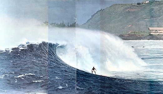
Wright (1971) page 9. Illustration by Bill Penarosa |
The one northern
anchorage, at Waimea Bay on the island of Ohau, was only for one night
(27 - 28 February 1779).
Given the modern
reputation of this location for big wave surf-riding at this time of the
year, it appears that Clerke's decision to relocate to Waimea Bay on Kaui
was sensible. See below.
Reference
The above details
of Cook's voyages were largely collated from Robson(2000).
This is a unique
work with a wealth of information in the form of maps, providing a wonderful
geographical context to Cook's voyages that is simply not possible from
written accounts.
Information specifically
relevant to Hawaii was selected from pages 154 to 155, pages 159 to 160
and the maps 3.12, 3.23, 3.24 and 3.25.
The Reports
Three excerpts are
attributed to surgeons - Anderson, Ellis and Samwell.
Two reports are
by naval officers Clerke and King, and one by a midshipman, GeorgeGilbert.
The journalists
served on
The final report,
attributed to King, is a construction by Rev. Douglas and bears little
relationship to King's report in Beaglehole (1967).
The locations are
also diverse
Clerke's report
of canoe surfing from Tahiti
The Format
I have attempted
to note the earliest publication of each extract and any subsequent reproduction.
These are not exhaustive.
The rank of the crew
members is given at the time of their report.
Note that after
Cook;s death there was a re-allocation of duties on both vessels.
I have made an attempt
to note the possible locations of the accounts, essentially by correlating
Finney
and Houston (1966) and Robson(2000).
An extended analysis
is included at Surf-riding Locations.
The quotations have their original spelling and grammar, however I have spaced each sentence to be consistent with my preferred monitor presentation (as illustrated here).
The biographical
notes are brief, with a focus on the the history of the publication.
I would like to
thank Alan Twigg, British Columbia,
for permission to quote from his extensive notes.
Where applicable, I have included some comments noting the research thread.
THE VOYAGES OF
JAMES COOK R.N.
James Cook lead
three scientific and exploratory expeditions to the Pacific Ocean for the
British Navy, from 1768 to 1780.
His achievements
were considerable.
The first voyage
(1768-1771), in the Endeavour, recorded the transit of Venus from
Tahiti, circumnavigated New Zealand and established the extent of the east
coast of Australia.
This largely disproved
a prevalent theory, Terra Australis incognita, of a massive southern
continent - ostensibly to balance those of the northern hemisphere.
The voyage was expertly
recorded (note Cook's superb mapping techniques) and returned a huge collection
of cultural and botanical specimens, largely due to Joseph Banks and Dr
Solander.
These elements were
also features of the subsequent voyages.
The second voyage
(1772 - 1775), in the Resolution accompanied by the Adventure,
firmly located the known islands of the Pacific ocean and discovered several
others.
It was probably
the first voyage below the Antarctic Circle and was terminal for the theory
of Terra Australis incognita.
The voyage emphatically
proved the worth of John Harrison's
maritime chronometer to calculate longitude and set new standards of naval
health care - of four deaths, only one crew member died of sickness.
Cook recognized
Polynesia as a distinct cultural entity and largely defined its massive
spread across the Pacific.
The third voyage
(1776 - 1780), also in the
Resolution but now accompanied
by the Discovery,
failed to locate the North West Passage but in
the process an extensive area of the North Pacific coasts was explored
and mapped.
Further Pacific
islands were discovered, notably the Hawaiian islands, where Cook would
be killed at Kealakekua Bay, Hawai'i on the 14th February 1779.
Command of the expedition
and the Resolution fell to Charles Clerke, the captain of the Discovery
who had sailed with Cook on his previous two Pacific voyages.
Lt. James King of
the Resolution was promoted to first lieutenant.
John Gore, Cook's
first lieutenant who had sailed on the Endeavour, took command of
the Discovery.
Other crew members of the Resolution included artist John Webber and Master William Bligh.
Clerke determined
that he should continue to fulfil Cook's orders and leaving Hawaii in March
1779, the expedition returned to the North Pacific.
Charles Clerke died
at sea on the 21st August 1779 and Gore took command of the Resolution
with King taking command of the Discovery.
Following the return
to England on the 4th October 1780, King was selected to edit the logs
and journals to prepare them for publication.
Reference
The above details
of Cook's voyages were largely collated from Robson(2000).
This is a unique
work with a wealth of information in the form of maps, providing a wonderful
geographical context to Cook's voyages that is simply not possible from
written accounts.
Information specifically
relevant to Hawaii was selected from pages 154 to 155, pages 159 to 160
and the maps 3.12, 3.23, 3.24 and 3.25.
THE PUBLICATION
OF COOK'S JOURNALS
"Usually cited
as the first European to set foot in British Columbia, James Cook posthumously
published the fifth earliest account in English of the first British landing
in British Columbia.
...
The British
Admiralty published an edited account of Cooks voyages in three quarto
volumes and a large atlas in 1784-1785, now generally known as 'A Voyage
to the Pacific Ocean'.
The journals
were heavily edited by Dr. John Douglas, Bishop of Salisbury.
As commissioned
by the Lords of the Admiralty, Douglas embellished much of Cooks original
journals with material gleaned from Cooks officers.
In particular,
Douglas extrapolated from Cooks reports of ritualistic dismemberment among
the Nootka, beginning the belief that the Indians engaged in cannibalism
when Cook had, in fact, described them as docile, courteous, good-natured
people.
Some of the
more sensational revelations added to the text were designed to encourage
the spreading of the blessings of civilization among the heathens and
to help sell books.
For almost
200 years Douglas version of Cooks writings was erroneously accepted
as Cooks own. Cooks journal, with its bloody ending supplied by James
King, proved popular.
Within three
days of its publication in 1784, the first printing was sold out.
There were
five additional printings that year, plus 14 more by the turn of the century.
Translations
were made throughout Europe.
The original
version of Cooks journal was edited by J.C. Beaglehole and finally published
for scholars in the 1960s.
It reveals
that Cook was a somewhat dull reporter, more interested in geography than
anthropology.
The profits
from the publication of Cooks journals went to the estates of Cook, James
King and Charles Clerke (Commander of the Discovery), with a one-eighth
share for William Bligh, master of the Resolution, because his surveying
work was so essential.
The irascible
Bligh wrote in ink on the title page of his own copy, 'None of the Maps
and Charts in this publication are from the original drawings of Lieut.
Henry Roberts, he did no more than copy the original ones from Captain
Cook who besides myself was the only person that surveyed and laid the
Coast down, in the Resolution. Every Plan & Chart from C. Cooks death
are exact copies of my works.'
Please pass this along as a response to Geoff Cater on early historical accounts of surfing.
In the course
I teach on surf history and culture (at Drury University), and in an anthology
that I've been putting together based on this course, I've come across
a number of these early accounts by Cook's mariners.
Several (including
the one you cite from David Samwell) can be found in the multi-volume _The
Journals of Captain
James Cook on his Voyages of Discovery_ edited by J.C. Beaglehole (Cambridge
UP, 1955-67).
Samwell's entry dates from January 22, 1779, and so possibly precedes King's, whose description takes place between their arrival on January 18 and their departure in March.
Besides the entries by Joseph Banks on Cook's first voyage (which Joe passed along not too long ago) and the famous description of Tahitian canoe riding by William Anderson (not James Cook) on Cook's third voyage, here are several more that may be of interest.
The earliest reference to surfridng appears to be from Charles Clerke, who took command of the Resolution after Cook's death. When Cook first touched in the Islands in 1778, Clerke registered the following comments at either Waimea, Kauai or Kamalino, Ni'ihau between January 19 and February 2, 1778:
"These People handle their Boats with great dexterity, and both Men and Women are so perfectly masters of themselves in the Water, that it appears their natural Element; they have another convenience for conveying themselves upon the Water, which we never met with before; this is by means of a thin piece of Board about 2 feet broad & 6 or 8 long, exactly in the Shape of one of our bone paper cutters; upon this they get astride with their legs, then laying their breasts along upon it, they paddle with their Hands and steer with their Feet, and gain such Way thro' the Water, that they would fairly go round the best going Boats we had in the two Ships, in spight of every Exertion of the Crew, in the space of a very few minutes. There were frequently 2 and sometimes upon one of these peices of board, which must be devilishly overballasted; still by their Management, they apparently made very good Weather of it."
Also in January
of 1778, William Ellis (Surgeon's Mate) recorded the following entry at
Waimea, Kauai (from An Authentic Narrative of a Voyage Performed by Captain
Cook and Captain Clerke in His Majesty's Ships Resolution and Discovery
(1782))
"Their canoes
or boats are the neatest we ever saw, and composed of two different coloured
woods, the bottom being dark, the upper part light, and furnished with
an out-rigger. Besides these, they have another mode of conveying
themselves in the water, upon very light flat pieces of boards, which we
called sharkboards, from the similitude the anterior part bore to the head
of that fish. Upon these they will venture into the heaviest surfs,
and paddling with their hands and feet, get on at a great rate. Indeed,
we never
saw people so
active in the water, which almost seems their natural element."
In February of
1779 (I'm assuming at Kealakekua Bay), Midshipman George
Gilbert recorded
this observation (from Captain Cook's Final Voyage: The Journal of Midshipman
George Gilbert (1982)):
"Several of those
Indians who have not got Canoes have a method of swimming upon a piece
of wood nearly in the form of a blade of an oar, which is about six feet
in length, sixteen inches in breadth at one end and about 9 at the other,
and is four or five inches thick, in the middle, tapering down to an inch
at the sides.
They lay
themselves upon it length ways, with their breast about the centre; and
it being sufficient to buoy them up they paddle along with their hands
and feet at a moderate rate, having the broad end foremost; and that it
may not meet with any resistance from the water, they keep it just above
the surface by weighing down upon the other, which they have underneath
them, betweeen their legs. These pieces of wood are so nicely balanced
that the most expert of our people at swimming could not keep upon them
half a minuit without
rolling off."
This last observation at leasts suggests that some of Cook's men may have tried paddling (or surfing?) on these boards themselves.
At any rate, the presence of these journal entries (more than have been noted in histories of Surfing) emphasizes (at least to my mind) the great fascination these mariners had with surfboards and surfing. Their detailed accounts of surfboard sizes, shapes, and purpose is an important (and mostly undiscovered) link in why and how surfing manages to survive when so many other native pasttimes did not.
All the best,
Patrick Moser.
Reply
I replied, mostly
detailing historical details that have been added to the above paper.
In response to Patrick's
final paragraph, I wrote ...
At any rate, the presence of these journal entries (more than have been noted in histories of Surfing) emphasizes (at least to my mind) the great fascination these mariners had with surfboards and surfing. Their detailed accounts of surfboard sizes, shapes, and purpose is an important (and mostly undiscovered) link in why and how surfing manages to survive ...
Very interesting ... I can only make some disjointed observations that may relect on this ...
More than a maritime
culture - an aquatic culture.
As mariners, the
journalists had a fascination with all things nautical - there are extensive
accounts that relate to canoes, seamanship and navigation.
Specifically, Cook
was amazed that the Hawaiians were there before he was and was the first
to suggest that Polynesian settlement was the result of extensive voyages
from the west - a feat that preceded his own voyages.
Given that some (unknown
proportion) of the crew could not swim at all (Cook and, I think, King
and note 7. above), Hawaiian familiarity with the ocean, where swimming
was a basic community skill, must have been impressive.
Obscure thought
- Could Cook have saved himself, if he was able to swim?
The origins of modern
swimming are difficult to ascertain - a restricted amount of research has
indicated to me that the development of the common crawl stroke (the Olympic
freesyle) has at least some import from Polynesian, especially Hawaiian,
swimming.
I would propose
that there is a technical relationship between 'native' swimming and board
paddling - the combined overarm stroke and flutter kick.
If this conjecture
has any validity, then (as Hawaiian surf-riding has now expanded across
all the world's oceans) Polynesian swimming has now expanded across the
world's oceans, lakes and swimming pools.
Surf-riding conditions
and locations
Confident of their
skills, the Hawaiians chose the most extreme conditions ( 'great swell'
-Samwell) for their 'diversion'.
Even in Hawaii,
good surf-riding conditions are not consistant, sublime conditions are
rare, large and sublime conditions even rarer.
If Cook had not
had extended stays, or if social relations had been mostly confrontational,
then we may not have these accounts.
However, note that
these accounts of prone riding seem mostly derive from Kealakekua Bay,
Hawaii.
Although this was
probably the most populous area, at this time (winter) the bay was protected
from the prominant swell direction from the north.
A significant number
of Hawaiian legends (see Finney (1996), Chapter 3) indicate that (the now
extinct) Hilo Bay, on the opposite coast of Hawaii, was a centre of surf-riding
excellence and exposed to the winter north swells, but none of the 1779
reports indicate knowledge of this.
The other legendary
centre was Waikiki, Oahu - exposed to the summer south swells and protected
from the north.
Photographic evidence
(Edison, circa 1905) confirms that the surf-riding conditions of Wakiki
for solid wood finless boards can be sublime.
If Cook was searching
for surf, then probably "he really missed it - he should have been there
six months ago!" (paraphasing Brown, 1966).
The wave as icon
For each riding
location ('surf break') there are specific features of paddle-out, take-off
and the general wave characteristics.
For each individual
wave another specific set of variables is operational.
Each wave (an animated
expression of climatic forces?) is structually, aesthetically and temporaly
unique in nature.
An early representation
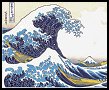
of the wave as icon is Katsushika Hokusai (1760-1849) : Under the wave
off Kanagawa c.1825?1831?
The wave as icon
retains its attaction in contemporary times - evidenced by the number of
photographs of riderless wavescapes that are regulary printed.
Surf-riding, wave-riding,
surf-shooting, wave-sliding, he'e nalu
Finney's list of
traditional Hawaiian riding and wave terminology (1996, Appendix A) and
the early written reports appear to confirm that traditional riders transversed
the wave face in the same manner as all subsequent riders.
The mechanics of
this are both highly complex (that is, I don't understand them) and highly
variable.*
For Cook's crew,
surf-riding was like no other previous experienced human activity - it
was unique.
In my opinion it
is still the case that surf-riding is an unique human activity.
*I have made one
(poor) attempt to deal with this problem ...
http://www.surfresearch.com.au/a_surfboard_dynamics.html
The surfboard
The Hawaiians further
advanced their activity by the development of specific craft to maximize
their wave-riding performance.
Board construction
was a combination of highly developed craftsmanship and an access to a
rich source of building materials - specifically the massive koa forests
of the Hawaiian islands.
This is easily seen
in the accounts of the number, the size and the quality of workmanship
of Hawaiian canoes.
The earliest surboards were hand-shaped objects (a sculpture) and despite the application of modern technologies, the basic surfboard retained hand-shaping at least until the end of the twentith century.
when so
many other native pasttimes did not.
Most native pastimes
had some European equivalent - board games, wrestling, running, sailing,
dance.
Hawaiian surf-riding
was a highly developed unique activity - and the waves are still there.
The Reports
Three excerpts are
attributed to surgeons - Anderson, Ellis and Samwell.
Two reports are
by naval officers Clerke and King, and one by a midshipman, GeorgeGilbert.
The journalists
served on
The final report,
attributed to King, is a construction by Rev. Douglas and bears little
relationship to King's report in Beaglehole (1967).
The locations are
also diverse
Clerke's report
of canoe surfing from Tahiti
The Format
I have attempted
to note the earliest publication of each extract and any subsequent reproduction.
These are not exhaustive.
The rank of the crew
members is given at the time of their report.
Note that after
Cook;s death there was a re-allocation of duties on both vessels.
I have made an attempt
to note the possible locations of the accounts, essentially by correlating
Finney
and Houston (1966) and Robson(2000).
An extended analysis
is included at Surf-riding Locations.
The quotations have their original spelling and grammar, however I have spaced each sentence to be consistent with my preferred monitor presentation (as illustrated here).
The biographical
notes are brief, with a focus on the the history of the publication.
I would like to
thank Alan Twigg, British Columbia,
for permission to quote from his extensive notes.
Where applicable, I have included some comments noting the research thread.
THE VOYAGES OF
JAMES COOK R.N.
James Cook lead
three scientific and exploratory expeditions to the Pacific Ocean for the
British Navy, from 1768 to 1780.
His achievements
were considerable.
The first voyage
(1768-1771), in the Endeavour, recorded the transit of Venus from
Tahiti, circumnavigated New Zealand and established the extent of the east
coast of Australia.
This largely disproved
a prevalent theory, Terra Australis incognita, of a massive southern
continent - ostensibly to balance those of the northern hemisphere.
The voyage was expertly
recorded (note Cook's superb mapping techniques) and returned a huge collection
of cultural and botanical specimens, largely due to Joseph Banks and Dr
Solander.
These elements were
also features of the subsequent voyages.
The second voyage
(1772 - 1775), in the Resolution accompanied by the Adventure,
firmly located the known islands of the Pacific ocean and discovered several
others.
It was probably
the first voyage below the Antarctic Circle and was terminal for the theory
of Terra Australis incognita.
The voyage emphatically
proved the worth of John Harrison's
maritime chronometer to calculate longitude and set new standards of naval
health care - of four deaths, only one crew member died of sickness.
Cook recognized
Polynesia as a distinct cultural entity and largely defined its massive
spread across the Pacific.
The third voyage
(1776 - 1780), also in the
Resolution but now accompanied
by the Discovery,
failed to locate the North West Passage but in
the process an extensive area of the North Pacific coasts was explored
and mapped.
Further Pacific
islands were discovered, notably the Hawaiian islands, where Cook would
be killed at Kealakekua Bay, Hawai'i on the 14th February 1779.
Command of the expedition
and the Resolution fell to Charles Clerke, the captain of the Discovery
who had sailed with Cook on his previous two Pacific voyages.
Lt. James King of
the Resolution was promoted to first lieutenant.
John Gore, Cook's
first lieutenant who had sailed on the Endeavour, took command of
the Discovery.
Other crew members of the Resolution included artist John Webber and Master William Bligh.
Clerke determined
that he should continue to fulfil Cook's orders and leaving Hawaii in March
1779, the expedition returned to the North Pacific.
Charles Clerke died
at sea on the 21st August 1779 and Gore took command of the Resolution
with King taking command of the Discovery.
Following the return
to England on the 4th October 1780, King was selected to edit the logs
and journals to prepare them for publication.
Reference
The above details
of Cook's voyages were largely collated from Robson(2000).
This is a unique
work with a wealth of information in the form of maps, providing a wonderful
geographical context to Cook's voyages that is simply not possible from
written accounts.
Information specifically
relevant to Hawaii was selected from pages 154 to 155, pages 159 to 160
and the maps 3.12, 3.23, 3.24 and 3.25.
THE PUBLICATION
OF COOK'S JOURNALS
"Usually cited
as the first European to set foot in British Columbia, James Cook posthumously
published the fifth earliest account in English of the first British landing
in British Columbia.
...
The British
Admiralty published an edited account of Cooks voyages in three quarto
volumes and a large atlas in 1784-1785, now generally known as 'A Voyage
to the Pacific Ocean'.
The journals
were heavily edited by Dr. John Douglas, Bishop of Salisbury.
As commissioned
by the Lords of the Admiralty, Douglas embellished much of Cooks original
journals with material gleaned from Cooks officers.
In particular,
Douglas extrapolated from Cooks reports of ritualistic dismemberment among
the Nootka, beginning the belief that the Indians engaged in cannibalism
when Cook had, in fact, described them as docile, courteous, good-natured
people.
Some of the
more sensational revelations added to the text were designed to encourage
the spreading of the blessings of civilization among the heathens and
to help sell books.
For almost
200 years Douglas version of Cooks writings was erroneously accepted
as Cooks own. Cooks journal, with its bloody ending supplied by James
King, proved popular.
Within three
days of its publication in 1784, the first printing was sold out.
There were
five additional printings that year, plus 14 more by the turn of the century.
Translations
were made throughout Europe.
The original
version of Cooks journal was edited by J.C. Beaglehole and finally published
for scholars in the 1960s.
It reveals
that Cook was a somewhat dull reporter, more interested in geography than
anthropology.
The profits
from the publication of Cooks journals went to the estates of Cook, James
King and Charles Clerke (Commander of the Discovery), with a one-eighth
share for William Bligh, master of the Resolution, because his surveying
work was so essential.
The irascible
Bligh wrote in ink on the title page of his own copy, 'None of the Maps
and Charts in this publication are from the original drawings of Lieut.
Henry Roberts, he did no more than copy the original ones from Captain
Cook who besides myself was the only person that surveyed and laid the
Coast down, in the Resolution. Every Plan & Chart from C. Cooks death
are exact copies of my works.'
| home | catalogue | history | references | appendix |
Volume 3
Chapter VII -- General Account of the Sandwich Islands Continued
AJ-130b-0158
Copyright & Access © Copyright 2003 by the Wisconsin Historical
Society (Madison, Wisconsin). For further information see http://www.americanjourneys.org/rights/
Page 145
Swimming is not only a necessary art, in which both their men and women are more expert than any people we had hitherto fees, but a favourite divert on amongst them. One particular mode, in which they sometimes amused themselves with this exercise, in Karakakooa Bay, appeared to us moft perilous and extraordinary, and well deserving a distinct relation.
The surf, which breaks on the coal round the bay, ex tends to the diftance of about one hundred and fifty yards from the shore, within which apace, the forges. of the fea, accumulating from the shallowness of the water, are dated against the beach with prodigious violence. Whenever, from stormy weather, or any extraordinary swell at sea, the impetuosity of the surf is increased to its utmost height, they choose
Page 146
... that time for this amusement, which is performed in the following manner: Twenty or thirty of the natives, taking each a long narrow board, rounded at the ends, set out together from the shore. The first wave they meet, they blunge under, and suffering it to roll over them, rise again beyond it, and make the best of their way, by swimming, out into the sea. The second wave is encountered in the same manner wiht the first; the great difficulty consisting in seizing the proper moment of diving under it, which, if missed, the person is caught by the surf, and driven back again with great violence; and all his dexterity is then required to prevent himself from being dashed against the rocks. As soon as they have gained, by these repeated efforts, the smooth water beyond the surf, they lay themselves at length on their board, and prepare for their return. As the surf sonsists of a number of waves, of which every third is remarked to be always much larger than the others, and to slow higher on the shore, the rest breaking in the intermediate space, their first object is to place themselves on the summit of the largest surge, by which they are friven along with amazing rapidity toward the shore. If by mistake they should place themselves on one of the smaller waves, which breaks before they reach land, or should not be able to keep their plank in a proper direction on the top of the swell, they are left exposed ot the fury of the next, and, to avoid it, are obliged again to dive and regain the place from which they set out. Those who succeed in their object of reaching the shore, have still the greatest danger to encounter. The coast being guarded by a chain of rocks, with, here and there, a small openin between them, they are obliged to steer their board through one of these, or, in case of failure, to quit it, before they reach the rocks,
Page 147
... and, plunging under the wave, make the best of their way back again. This is reckoned very disgraceful, and is also attended with the loss of the board, which i have often seen, with great terror, shred to pieces, at the very moment the islander quitted it. The boldness and address, with which we saw them perform these difficult and dangerous manoeuvres, was altogether astonithing, and is scarccly to be credited.*
An accident of which I was a near spectator, shews at how early a period they are fo far familiarized to the water, as both to lose all fears of it, and to fet its dangers at defiance. A canoe being overset, in which was a woman with children, one of them an infant, who, I am convinced, was not more than four years old, seemed highly delighted with what had happened, swimming about at its case, and playing a hundred tricks, till the canoe was put to rights again.
* and amusement, somewhat similar to this, at Otaheite, has been described Vol II page 150.